It has been a long-held dream of the “Grimentz Rambler” since her arrival in Switzerland 10 years ago to walk the Haute Route. In 2018, the intense heatwave in Europe and long periods of settled weather meant that the goal of hiking the route appeared to be a sudden possibility for this keen hiker.
Read her report on whether this possibility became a reality!
Zermatt or Bust
“My two sons Tom and Marcus (based in the UK) were also keen to take part in my adventure, so it was going to be tricky to organise this so quickly (most people take a year to prepare such a trip!) But good advice came from Jay, a former experienced ski-tourer and mountaineer. When she asked me how much of the Haute Route I was familiar with. I listed all how many of its sections I had already completed. “The thing to do,” said Jay, “is to simply hike the final section of the route from Zinal.”
So, this seemingly impossible-to-organise hike from Chamonix to Zermatt had morphed into something much more manageable: a 4-day trek from Zinal to Zermatt, comprising most of the Tour du Mont Cervin (Tour of the Matterhorn). It seemed an excellent compromise. We decided on August 9 to 12 for our 4-day hike and got organised.
Preparation for the walk
At Là-Haut, my favourite ski and hiking shop in Sion, I invested in a sturdy 40-litre backpack, as well as sorting out maps, provisions and a first-aid kit. The rest of my days were filled with local training hikes that were as ‘hard-core’ as I could achieve: 4 to 5 hours at a time, rocky paths, 900m ascent/descent. Most of this was done in a persistent heatwave.
Thursday: Day 1 – A sunny start, a heavy backpack and a squashed dormitory
Zinal to Gruben (Zinal valley to Turtmann valley): 8hrs hiking; around 16km; 1200m ascent / 1000m descent. Highpoint: Forcletta pass (2870m)
It was a beautifully clear blue morning as we set off from the centre of Zinal at around 09:30. We were all dressed in our usual summer mountain gear: shorts and t-shirts, sunhats, trusty hiking boots. I carried my batons in my hand as we made our way up the middle of the village, past the church, apartment blocks, through a tunnel and then steeply uphill on the zigzag forest path (full of roots, rocks and loose gravel). We were now puffing up the vertiginous path the runners hurtle down in the final section of the annual Sierre-Zinal mountain race. By the time we reached the contour path that follows the shape of the mountain and leads due north towards the Weisshorn Hotel at around the 2350m level (700 vertical metres above Zinal), I was exhausted.
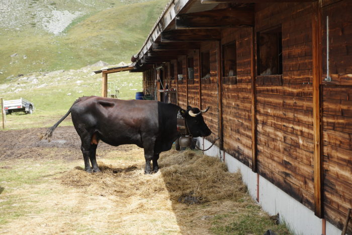
Crossing two torrents, we turned off at the signpost and marched resolutely eastwards up a long stony valley, stopping for a break in the company of a beautiful black Race d’Hérens cow tethered by a barn at the Alpage de Barneuza (around 2500m). It was a struggle from there, but the boys kept encouraging me to keep going. The 11kg/24lb weight of my backpack was really starting to tell, used as I was to day-hikes with a small daypack.
Crossing the linguistic border and squelching over water-filled paths
It took us 5 hours to ascend the 8km and 1200 vertical metres from Zinal to reach the rocky top of the Forcletta pass (including stops), by which time the cloud had descended in swirls and the temperature dropped to some 10C. The 8km descent down a long, stony valley marked not only our entrance into the Turtmanntal—a nature reserve that apart from a couple of villages is as devoid of humans as the Val de Réchy—but also the linguistic border between French-speaking Valais and Swiss-German-speaking Wallis. An hour down from the top of the col, near to a collection of Alpine farmhouses, the weather closed in. As we hurried to don over-trousers and lightweight anoraks with hoods, pulling the gaudy waterproof covers over our backpacks, the rain fell in torrents. It didn’t let up all evening, meaning that our two-hour descent through high pastures and the then steep forest was underscored by our boots squelching and sliding on the slippery, rock-strewn, water-filled path. I didn’t like it at all, but the boys were very sure-footed—even carrying my pack for me over the final two kilometres of valley trail to our first overnight stop.
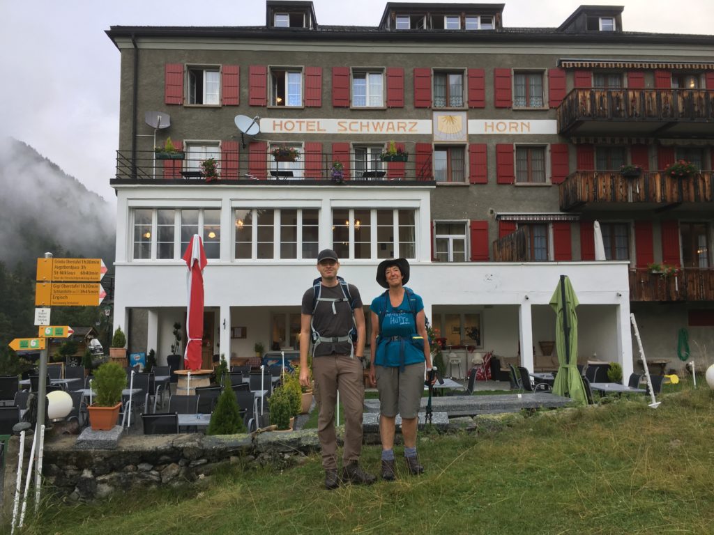
Photo above – Outside the Hotel Schwarzhorn, ready for a 08:00 start
It was well past 17:30 by the time we stood dripping at Reception in the Hotel Schwarzhorn. The boys had been allocated their own ‘double’ room, sharing a shower between three other rooms. But I was upstairs in one of the two dortoirs under the eaves—12 mattresses on the floor squashed into two tight rows; hooks outside in the corridor on which to hang your backpack; one loo, a basin and two showers to share between 24 people. Lesson number one when hiking in the mountains in August: arrive early at your destination. Every hook had been taken, while the whole place was heaving with people. I managed to change into a spare t-shirt and walking trousers, placed soaking boots and sticks on the landing, and went down to find the boys.
Despite the crowded conditions in the hotel, their meal arrangement worked very efficiently, and after a piping hot soup, salad, rice dish and crème caramel, the three of us felt our spirits much restored. Combined with a subsequent hot shower each we managed to get a few hours’ sleep.
Friday: Day 2 – Eating sandwiches in the fog and spotting an Ibex
Gruben to Grächen (Turtmann valley to lower Mattertal): 7hrs hiking; around 16km; 1100m ascent / 1100m descent. Highpoint: Augstbordpass (nearly 2900m)
The rain had stopped by the time we woke around 06:00, the air was fresh and the entire valley and mountainsides wreathed in clouds. Fortified with a simple but plentiful Swiss breakfast we packed up and were ready to set off at 08:00. My boots were still soaking wet. The path led eastwards and upwards from directly outside the hotel, zigzagging up through the forest. Emerging above the tree-line, we found ourselves ascending a long, stony valley divided by a tumbling torrent that we had to cross over several times. We could see the top of the col in the far distance, but our views kept being disrupted by continually swirling cloud amid tantalising glimpses of blue sky
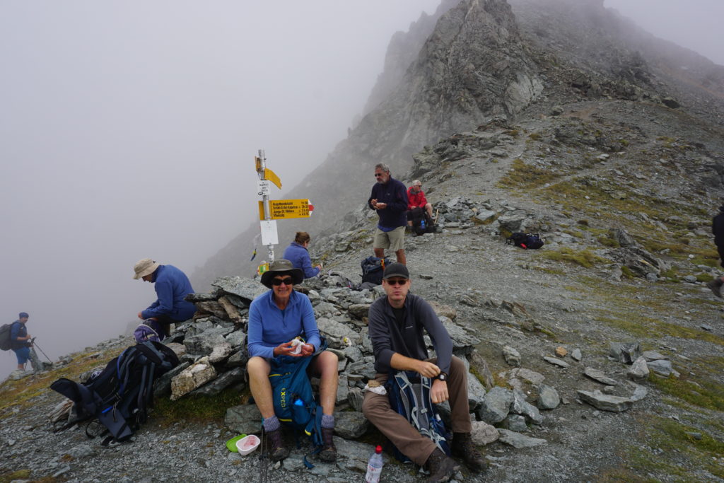
Photo above – The Augstbordpass at nearly 2900m, temperatures down to 6C
Getting into our stride, we were scrambling up the steep cliff-face at the end of the valley by 11:00. But there was another half-hour of further climbing to go before we finally made it to the summit of the pass itself. By this time the fog was really closing in, and it can’t have been more than around 6C. Together with a few fellow-walkers, we sat in our fleeces on the stones by the signpost and devoured the bread-and-cheese we’d saved from breakfast.

Photo above – The long climb to the valley head, clouds descending
A tricky and hard descent
For me, the descent was far harder than the ascent. A long hanging valley stretched out before us, the path forming a steep zigzag amidst rocks, scree and rubble. I was mightily glad of my hiking batons, but it was hard-going on the knees. After crossing a sizeable patch of snow, we spent the next 90 minutes or so negotiating the longest section of ‘boulder-field’ I have ever been on. The boys strode ahead as usual, while I stumbled across uneven rocks and did my best not to misplace my feet or sprain my ankle. The path led right around the mountain on more or less the same contour, so that by the time we finally emerged onto a grassy alp above the tree-line, we were still at 2500m. For a few seconds during those difficult hiking conditions, the clouds cleared enough for us to catch a first fleeting view of the Ried Glacier on the eastern flank of the Mattertal. And a short while before that sight, a soft cry from Marcus had made us look up—and there silhouetted against the clouds was an ibex perched on the cliff-top, the first one I’ve seen in the wild.

Photo above – Our first glimpse of the Riedgletscher (glacier) amid swirling clouds
I knew another 700 vertical metres of descent through the forest lay ahead of us, before we reached Jungen. It had taken us nearly three hours down from the pass, but there was the Alpine village below us, perched on a steep cliff above the Mattertal. We had made it just in time, as the little cable-car from Jungen down to St Niklaus would be leaving in 15 minutes’ time at 15:00. We just managed to squeeze into the rickety 4-man ‘bubble’, but it was certainly worth the fare of 12 francs each to save a further 90 minutes of walking and 600 vertical metres to reach the valley floor. By now the clouds had cleared, and we walked to the station in St Niklaus in some 30C of heat and blazing sunshine.
That night we stayed in the Alpha B+B. This was a half-hour bus-ride up the mountain to the village of Grächen, so that night we luxuriated in a clean room with balcony and annex—me in a double bed, the boys in bunk beds—where we were able to dry out all the wet stuff, have showers, do washing, and find a friendly restaurant for supper. We all slept well.

Photo above – The 4-man cable car that took us down to St Niklaus
Saturday: Day 3 – Snowfields, Spectacular Glaciers and Minestrone Soup
Grächen to Europa Hut (first half of Europaweg): just over 7hrs hiking; around 15km; 1100m ascent/500m descent. Highpoint: around 2750m
Our friendly hostess had allowed us to come down to breakfast at 07:30, half an hour earlier than their usual schedule, and we were packed and ready to leave by 08:30. We walked on the road, in clear blue skies but initially cold air, through the village of Grächen. The starting point for the Europaweg is the local church (altitude around 1600m), which meant that we would be hiking the whole 33km of the famous high-mountain trail. Our route took us through the village of Gasenried and beyond, into the forest where we walked over a bridge across the torrent that tumbles down from the Ried Glacier. Here we turned left onto the steep forest path taking us in a series of looping zigzags up the mountain. By 11:30 we had emerged from the tree-line and were ascending a high pasture covered in myrtle and juniper bushes. To our left stood the imposing statue of St Bernard, apparently watching over the fate of all hikers.

Behind him emerged the glittering spectacle of the glacier—a mass of jagged blue icefalls, impressive crevasses and white snow-fields.
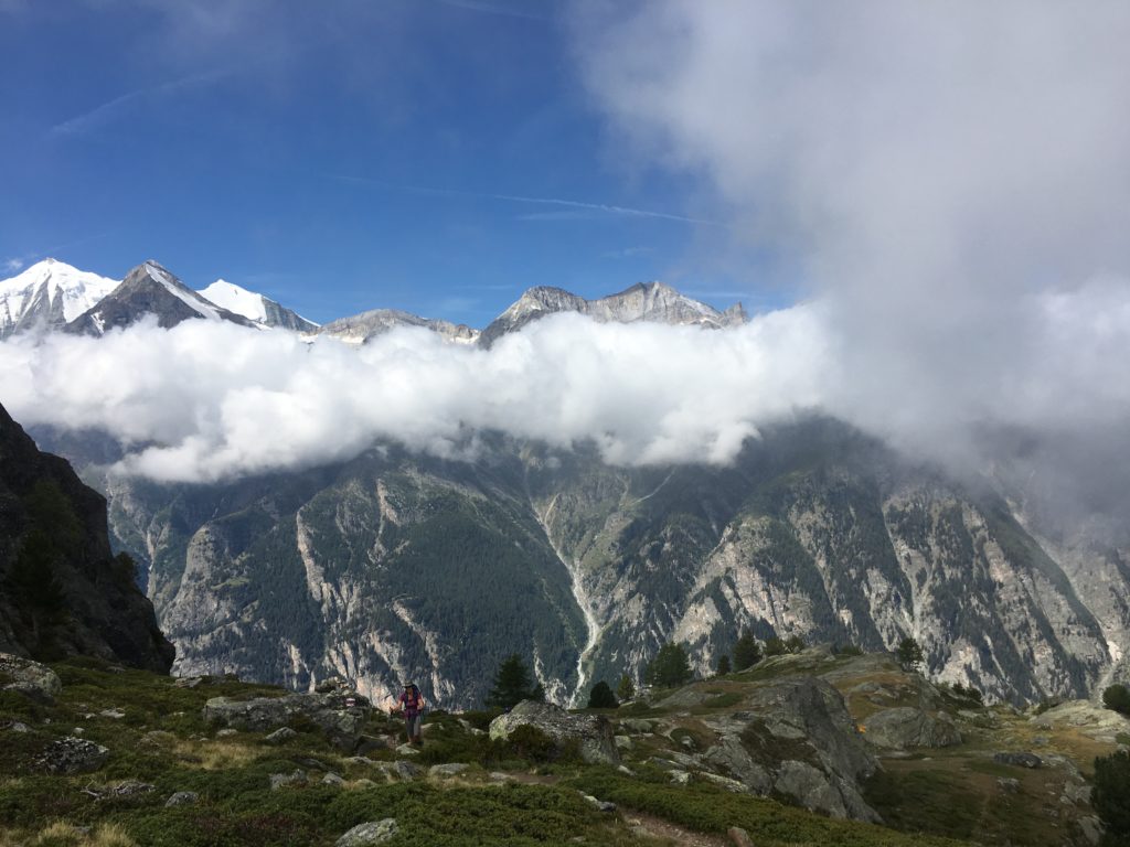
Photo above – Ascending the 900vm from Grächen to the start of the Europaweg.
The Europaweg – not for the faint-hearted
Our path was still ascending, but we had turned southwards as the landscape became ever more rugged and rocky. Now we were on the Europaweg proper: a narrow, stony path seemingly etched into the sheer cliff-face, at some 1000m above the valley-floor. Several sections had a kind of rope handrail to cling onto, with narrow wooden planks straddling the places where the scree was simply too unstable. This was certainly not for the faint-hearted or those suffering from vertigo (in fact there are severe warnings on the topic in the Cicerone guide). The boys leapt ahead like mountain goats, relishing the challenge of the rugged terrain, but they always made sure I was in range of their line of sight. The skyline of the western flank of the Mattertal was constantly changing opposite us, as our high-level path wound around the contours and we clambered over boulders, rocks, scree and loose stones.
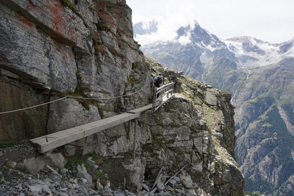
Photo above – A wooden bridge spanning the vertical cliff-face
Reaching the highpoint
After a rudimentary picnic sitting on a large rock at the end of an exposed rockfall section, Marcus consulted the map and told us we’d probably reached the highpoint of the trail. The descent of 500 or so vertical metres, however, was no less rugged than the trail so far, and the steep and rocky, root-strewn and stony path carried on all the way until our first sight of the Europa Hut. It’s perched at 2250m on a boulder-covered hillside just below the treeline, directly above the village of Randa in the valley below. It was nearing 17:00 by the time we gratefully dumped our backpacks on the floor, stretched our aching arms and shoulders, removed our burning feet from our dust-covered hiking boots, and dug out a pair of Crocs each from a basket in the entrance hall of the hut. We had endured 5 hours of nothing but rocks and stones under our feet, and would be mightily glad to be able to sit down.

Photo above – The rewards of the Europaweg with constantly dramatic views along the Mattertal
It was our first experience of overnighting in a Swiss mountain hut since my arrival in the country, it was Saturday evening, and I was quite aware that every bed had been taken. Our accommodation was in one of the three dorms upstairs, ours consisting of 12 bunk-beds rammed together and our party being allocated three top bunks in the middle of the row. There was a pillow and two ‘army-style’ horse-hair blankets each, while our backpacks could be stored in one of the large wooden slots along the wall in the corridor outside. There were two toilets downstairs—non-flush compost ones to save water—and showers were 4 francs for 2 minutes so we decided not to bother. Managing to change into our usual spare t-shirt and trousers, we sat outside on the terrace that faces the western flank of the Weisshorn. It became cool in the shade, but we enjoyed sharing a full litre-and-a-half of Rivella plus mineral water. I expected the hut to be full, but I was astonished at the level of noise and the amount of beer that the other hikers were drinking. Dinner was served at 18:30 with us sitting in groups of 8 or 10 in the main room, on long benches at long tables. Minestrone soup, another rice dish and the inevitable crème caramel were all a welcome ending to a strenuous but ultimately satisfying day.
Sunday: Day 4 – Walking in suspension, a view of the Matterhorn and greeted by yodellers.
Europa Hut to Zermatt (second half of Europaweg): 9hrs hiking; around 18km; 500m descent / 500m ascent / 600m descent. Highpoint: around 2250m
It came as no surprise to any of us that sleep was almost impossible. Marcus and I stood out on the terrace at 06:00 in the early-morning freshness, watching the sunrise. Half an hour later the three of us were standing in line to collect the usual rudimentary but plentiful mountain breakfast: coffee made with powder from a huge tin, UHT milk, thick slabs of bread, a bowl of muesli, slices of cheese. There must have been 50 hikers packed into the hut that night, but within the hour everyone had been fed and some were already setting off along the next section of the trail.
We were ready by 08:00, our first challenge being to cross the Charles Kuonen bridge that can already be seen below the Europa Hut. This is the longest pedestrian suspension bridge in the world, constructed entirely out of steel ropes, and stretching across the boulder-strewn mountainside for almost half a kilometre. The boys went ahead, gleefully taking pictures of each other and the surroundings. I followed behind somewhat more cautiously. However, as soon as you step onto the bridge it starts wobbling and bouncing, and this disconcerting movement doesn’t stop until you reach the other side.

Photo above – The Charles Kuonen pedestrian suspension bridge (opened July 2017)
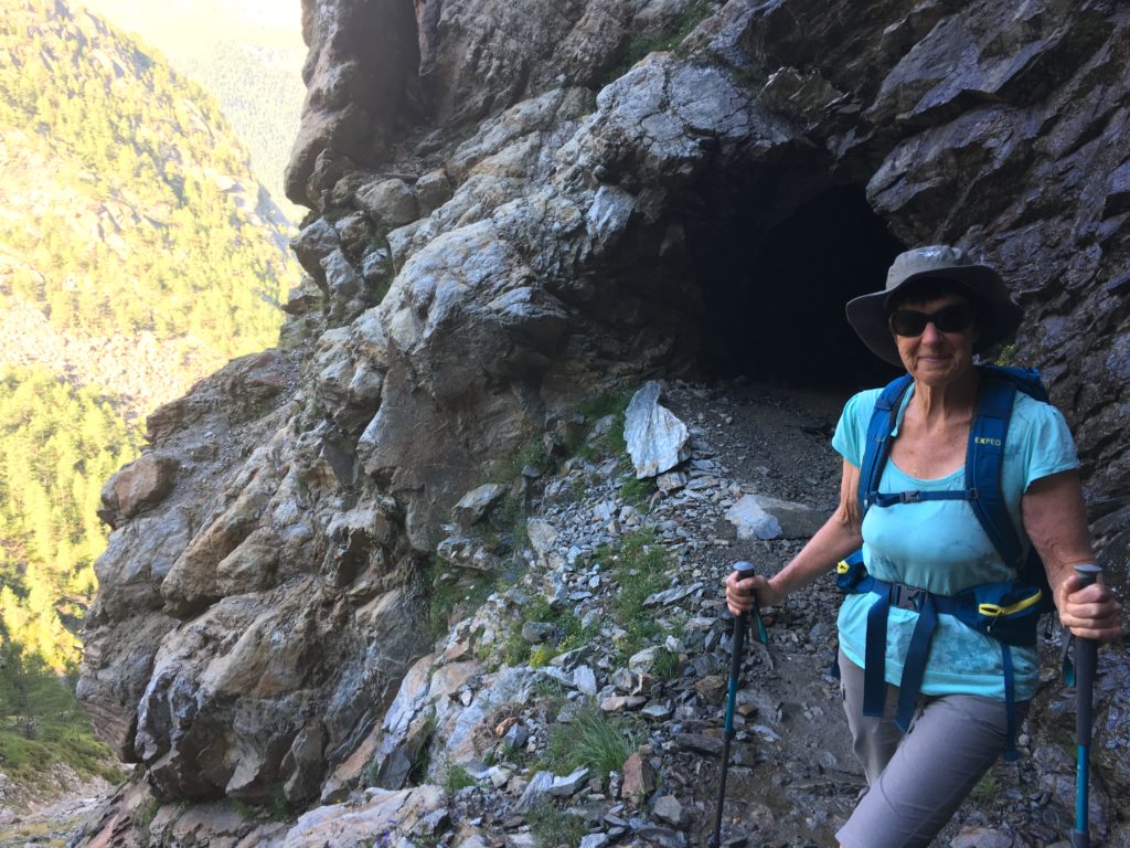
The path then carries on the descent, as far down as the 1750m level. Here we encountered something I’d never experienced in Switzerland before: a broad stretch of rockfall where the path was protected by a long, overhead concrete ‘roof’, followed by a series of large drainpipes acting as tunnels. In one section further along there were no less than three ‘rock-shelters’—again the large drainpipes—pushed into the mountainside and for use in case the rocks start tumbling. This whole area is known as the ‘Randawang’. By now we realised how ‘cruel’ this path was, because we were starting to ascend again, knowing we’d have to get back up to the 2250m level. Here the landscape turned into a solid cliff-face by a terrifyingly vertiginous cleft in the mountain. I couldn’t imagine how we would get around it, but before I knew it we were walking through a *tunnel hewn into the rock, lit by solar lighting and dripping with water at its exit. The path then led dramatically along the cliff-face and across a raging torrent, continuing in a long loop around the mountain and towards our midday stop: the Europaweg restaurant. We had a good long break there, sitting under a parasol on their pleasant terrace, the boys sharing a portion of cheese-and-bread served on a wooden platter.
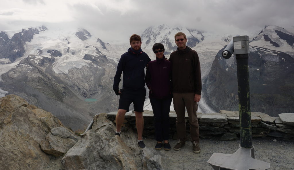
*You can see the tunnel, and the Grimentz Rambler in the photo at the top of this article.
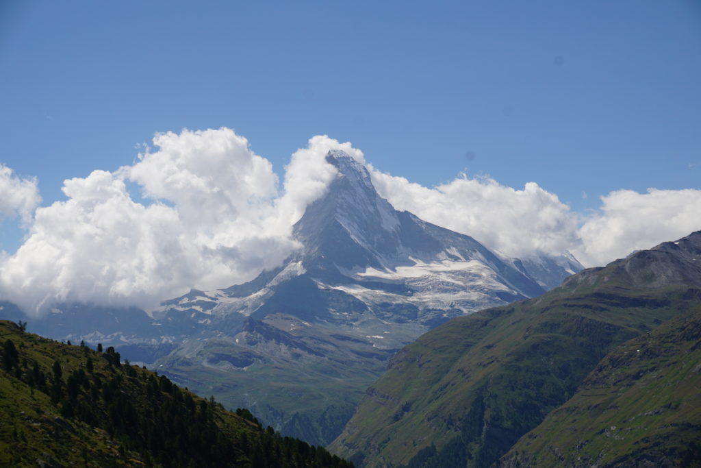
It was the best weather so far, with deep blue skies above us and the far mountains wreathed in white cloud-masses. Our first sight of the Matterhorn, with its snowy north face emerging from the clouds, was simply splendid.
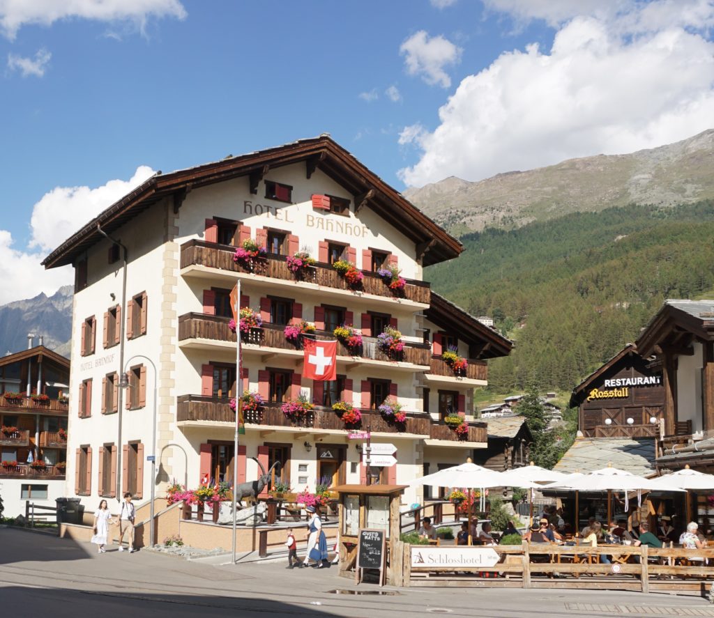
The path now became ‘gentler’, crossing over high pastures and past shepherd’s huts, until we finally reached the last stop at Tufteren, a collection of traditional little farmhouses fortuitously including a café to provide us with drinks and a slice of Aprikosenkuchen. From there it was about an hour and a half to hike down through the forest, finally arriving at our last overnight stop, the Hotel Bahnhof. Our entrance into the large town of Zermatt was greeted by the tail-end of their Folklore Festival, so the streets were thronging with oompah bands, groups of yodellers in traditional costume, and tourists from every corner of the world. We made sure to pass by the parish church of St Mauritius—where the Europaweg officially ends—pointing out the tomb of the unknown climber in the graveyard.

Photo above – The memorial to the unknown climber, in the graveyard of St Mauritius, the end-point of the Europaweg
At the Bahnhof Hotel I had a single room on the top floor, the boys had a double on the floor below me, the whole establishment being simple but clean and friendly.
After much-needed and very welcome hot showers, we went back out into the main street to find the Pollux hotel (recommended by our helpful receptionist), where we ate heartily —Rösti for Marcus, croûte for Tom, plus a side-order of frites each—and a large salad from the buffet for me. We celebrated our achievement: around 65km of mountain-hiking in 4 days from Zinal to Zermatt, with hardly a blister between us. We all slept well that night.
Monday: The day after
Sunday’s fine weather had deteriorated into darkly clouded skies, but I took the boys up the Gornergrat cog-railway nevertheless, to have our pictures taken at the 3100m level by the Gorner Glacier. It poured with rain with the Matterhorn totally obscured, so we returned to the station to take the 13:30 Matterhornbahn to Visp, the train to Sierre, and the Postbus up to Zinal, finally walking back into my chalet in Grimentz at around 15:00. The boys returned to England the following day, already enthusiastic to face the next challenge with their mother.
It was not a bad achievement for my 65th year, only 15 months after the total replacement of my left hip. After all, I had only been adhering to my Sion consultant’s advice following the operation: “marcher, marcher, marcher”.
All photos courtesy – Caroline Thonger, Tom and Marcus Lemberger.
Technical details
- Essential equipment
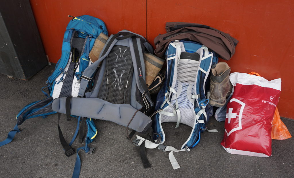
We each had similar-sized backpacks, amounting to 11kg/24lb in weight. The minimum needed for 4 days of hiking:
- A sturdy 40L backpack, with at least 3 ‘drypacks’ to keep clothes dry inside, spare plastic bag for dirty laundry, waterproof cover. The best feature of my pack is a front-opening zip giving easy access to items inside (eg first-aid kit), plus plenty of ‘hidden’ pockets
- Wet weather gear: over-trousers, lightweight anorak with hood, woolly hat and gloves, lightweight fleece
- T-shirts, socks, pants for 4 days, spare t-shirt, hiking trousers and deck-shoes for evening, sunhat (we all wore hiking shorts over the 4 days)
- First-aid kit: I had ‘one of each’ including Bandaids, bandage, scissors, antiseptic wipes, plus a selection of painkillers/Aspirins, putting smaller items into ‘baggies’ and the whole kit packed into a 1 litre freezer bag. Also Factor 50 sun-spray.
- Whistle, compass, maps, guidebook, mobile phone with charger—but there was frequently no signal until we’d reached our destination. Marcus took his camera.
- Telescopic hiking batons — essential for me, especially on steep downhill sections.
- Sturdy water-bottle (Marcus had a bladder+tube, Tom used 3 half-litre plastic bottles, I had an aluminium flask
- Small wash-kit (toothbrush, small toothpaste, face cloth )
- Accommodation
Booking ahead was essential, and we were extremely lucky to find 3 beds in the Europa Hut due to a recent cancellation. Most mountain hotels and mountain huts are online, but sometimes you need to phone them (most staff speak rudimentary English) Approx prices in brackets),
- Hotel Schwarzhorn—Gruben (DBB CHF 70 pp)
- Alpha B+B—Grächen (B+B CHF 70pp)
- Europa Hut—Randa (DBB CHF 80)
- Hotel Bahnhof—Zermatt (Bed only CHF 70pp)
- Mapping / information
I obtained the official Swiss 1:25000 maps from the local tourist office (14 francs each), but most Swiss sports shops will provide them as well. These were:
- Vissoie
- St Niklaus
- Randa
- Zermatt
- Matterhorn (not for the walk, but to identify the surrounding mountains)
We also used the “Chamonix to Zermatt” Cicerone guide by Kev Reynolds (pub 2007, updated 2011), which provides excellent descriptions of the hikes (with alternative routes).
Marcus also had an altimeter on his watch, but it ran out of battery after the first day. For most of the hike, the paths were well marked (with red-and-white striped markers), with signposts at significant crossroads. However, if conditions had been ‘whiteout’ fog a compass would have been essential (I always carry one, plus an emergency whistle).
- Provisions
- Needing to keep the weight of our backpacks to a minimum, I provided dried berries and various whole nuts, divided up into little baggies, plus around 12 ‘bio energy bars’ bought in Coop.
- I took CHF 1000 in cash as an emergency ‘stash’ (well-hidden at the bottom of my backpack). Hotels will charge for credit cards. The Europa Hut only takes cash.

Caroline, I am completely bowled over! You touched on the great adventure when we met in Sion last month, but reading your story brought home just how hard the journey was.
You are truly very gutsy & finest example any ‘new hip doubter’ could meet !
Many congratulations,
Celia